


Home | Trail Rides | Personal | Links | Guestbook | Amazon.com| Site Info
| |
 |
|
| |
|
|
| |
|
|
| |
|
Lake Tahoe, Sierra Nevada, Tahoe Rim Trail, Pacific Crest Trail, Desolation Wilderness, Carson Iceberg Wilderness, Mokelumne Wilderness, Horses, Horseback Riding, Trails, Camping, Horse Packing, Hiking, Peaks, Meadows, Lake, Streams...indescribable beauty!Big Meadow TrailheadHorseback riding in the Lake Tahoe area and the Central Sierra is nothing short of spectacular! Check out this trail:Big Meadow to Star Lake
Trail Description: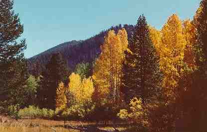 Follow the Tahoe
Rim Trail (TRT Home Page here) back through the parking lot, following
the Rim Trail logo (a blue footprint painted on the pavement). The sign
says Star Lake is 14.5 miles, but it will seem longer! The trail crosses
a creek, the outlet of Grass Lake, and begins a gentle climb with switchbacks
up for about two miles. Here you'll encounter the junction of the Tahoe
Rim Trail that leads back down to the top of Luther Pass, which is another
trailhead that leads directly up from the Highway, but has mininal parking.
There's another water opportunity in this creek on the right. Continue
up, up, and up some more!
Follow the Tahoe
Rim Trail (TRT Home Page here) back through the parking lot, following
the Rim Trail logo (a blue footprint painted on the pavement). The sign
says Star Lake is 14.5 miles, but it will seem longer! The trail crosses
a creek, the outlet of Grass Lake, and begins a gentle climb with switchbacks
up for about two miles. Here you'll encounter the junction of the Tahoe
Rim Trail that leads back down to the top of Luther Pass, which is another
trailhead that leads directly up from the Highway, but has mininal parking.
There's another water opportunity in this creek on the right. Continue
up, up, and up some more!
This trail is gentle enough to trot most of the way, yet it gains elevation quickly and can be a challenge for unacclimated horses. This is one of the most beautiful single-track trails I've ever ridden on, and soon it will encircle Lake Tahoe for an entire 150 miles. *Note: The last segment of the Tahoe Rim Trail was just completed, Sept. 2001* When you come to the junction (2.2 miles further) of Saxon Creek, better known as Mr. Toad's Wild Ride on your left, proceed straight ahead (east) and continue climbing! Freel Meadows is 1.4 miles later. Graze along the edge, but don't venture in as this meadow is boggy most of the year. Climb a bit more, then pull over to the left and gaze into Hell Hole. Despite the name, the view is Heavenly! Below is Fountain Place Meadow, in the distance is Lake Tahoe (did you guess right?), and across the void below, you may be able to pick out the Tahoe Rim Trail as it traverses high above Fountain Place. You'll be riding below a huge rock face. Don't drool for too long here, however, as the views get better and better! Around the ridge, expansive views of Hope Valley, Picket's and Hawkin's Peaks, and south to Markleville Peak, then beyond to Raymond and Reynold's Peaks at Ebbetts Pass (California's Highway 4) come into view. Take time for pictures here. Farther south, if it's clear, you can even see the Sweetwater Mountains, between Topaz, NV. and Bridgeport, CA. But, wait, you're only halfway to Star Lake! Continue on to Armstrong Pass. If problems arise, you could ride left down to Fountain Place and follow the pavement all the way back to Pioneer Trail and get help. Or, a couple hundred feet further, turn right and head down Willow Creek all the way, 5.3 miles back to Highway 89 in Hope Valley. Nearest phone is at Sorenson's Resort (left at the 88/89 junction). But if everything is going great, continue on towards
Star Lake. After lunch at Star Lake, turn back and retrace your hoofprints to Luther Pass (a 30 mile round trip trail ride!), or continue on to Stagecoach and take a cab back to Luther Pass! (Just kidding.) The best thing would be to get your riding partners together and leave a 4-horse trailer at Stagecoach and then trailer around to Luther Pass and ride all the way through. See Tahoe Rim Trail, Stagecoach section *coming soon* for details of the rest of the trail. As a straight through shot, the total miles are only 22. I have done the trail from Luther to Star Lake and back again many times. It can be quite long and the last downhill sections back to Luther can be hard on an already tired horse. The best way to do the trail is point to point. At any rate, this trail really is the best for scenery I have ever ridden. A few words of caution: If there are to be afternoon thundershowers, plan to be done with the ride by early afternoon. It also helps to have a calm, sure-footed trail horse. The trail is a narrow single-track. Many people use this trail; mostly mountain bikes. Keep alert. Be aware, that if you continue on to the Stagecoach trailhead, you will be traversing back and forth, in and out of the Heavenly Ski Area. Heavenly uses an old length of black and orange nylon rope to mark their boundary. This rope is slung between the treesand across the trailright at neck level for the average rider! Keep an eye out for the rope! It crosses the trail three or four times. Created by: Deanne Del Vecchio, of Tahoe Design Concepts.com Copyright © 1996 - 2006, by Deanne Del Vecchio. All Rights Reserved. Site Originally Created October 24, 1996. 
|
Where I am when I'm not riding: http://www.tahoewebhost.com or http://www.tahoedesignconcepts.com
 A
fence for the cattle, with a horse gate, is up ahead (since removed). After that,
views will open up again to the west. Pick out the South Lake Tahoe
Airport, Twin Peaks, the Crystal Range in Desolation Wilderness and
the American River drainage. Continue trotting! When you finally gain
the next saddle (no pun intended), you'll be overlooking High Meadows
and the back side of Monument Peak at Heavenly Valley Ski Area. Look
for the power line that runs over the next saddle. It goes from Minden
to South Lake Tahoe and supplies our main power. Past that saddle
the Tahoe Rim Trail continues on to the Stagecoach Lodge trailhead
at Heavenly Valley Ski Area on Kingsbury Grade, Nevada. You'll also
see Freel Peak to your right. At 10,881 feet elevation, it is the
highest peak in the Tahoe Basin and the highest in El Dorado County.
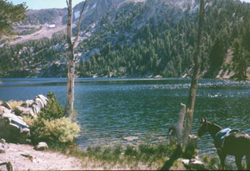
Star Lake is a mere 2.25 miles farther. This little gem of an alpine
lake snuggles in tight at the base of Job's Sister, elevation 10,823.
As you ride along this section of trail, notice all the white quartz
around. There are beautiful large chunks everywhere. Scan for crystals
but don't take any. This area is considered sacred by the Washo Indians.
A
fence for the cattle, with a horse gate, is up ahead (since removed). After that,
views will open up again to the west. Pick out the South Lake Tahoe
Airport, Twin Peaks, the Crystal Range in Desolation Wilderness and
the American River drainage. Continue trotting! When you finally gain
the next saddle (no pun intended), you'll be overlooking High Meadows
and the back side of Monument Peak at Heavenly Valley Ski Area. Look
for the power line that runs over the next saddle. It goes from Minden
to South Lake Tahoe and supplies our main power. Past that saddle
the Tahoe Rim Trail continues on to the Stagecoach Lodge trailhead
at Heavenly Valley Ski Area on Kingsbury Grade, Nevada. You'll also
see Freel Peak to your right. At 10,881 feet elevation, it is the
highest peak in the Tahoe Basin and the highest in El Dorado County.
Star Lake is a mere 2.25 miles farther. This little gem of an alpine
lake snuggles in tight at the base of Job's Sister, elevation 10,823.
As you ride along this section of trail, notice all the white quartz
around. There are beautiful large chunks everywhere. Scan for crystals
but don't take any. This area is considered sacred by the Washo Indians.